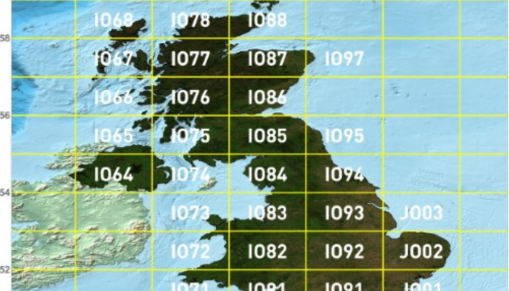
Maidenhead Grid Squares Unlocking the Airwaves
When it comes to global positioning, most people think of GPS coordinates or perhaps traditional maps. However, there is another system that holds particular significance in the world of amateur radio and geographic information: Maidenhead Grid Squares.
What Are Maidenhead Grid Squares?
Maidenhead Grid Squares, also known simply as grid squares, are a method for encoding positions on Earth. This system was developed by Dr. John Morris and his colleagues at the Maidenhead conference in England in 1980, which is how the system got its name. It has since become a standard for amateur radio enthusiasts and others who require a straightforward way to describe locations anywhere in the world.
How Does the System Work?
At its core, the Maidenhead Grid Square system uses a series of letters and numbers to form a unique identifier for any given location. The Earth is divided into a grid of squares that are 1-degree latitude by 2-degrees longitude. These squares are then sub-divided into smaller squares using a set pattern of letters and numbers.
The system works as follows:
1. Fields: The largest unit in the Maidenhead system is a “field,” which is designated by two letters (e.g., FN, EM). Each field covers 10 degrees of latitude and 20 degrees of longitude.
2. Squares: Each field is divided into 100 smaller squares, identified by two digits (e.g., FN31, EM75). These squares measure 1 degree latitude by 2 degrees longitude.
3. Sub-Squares: Each square can be further divided into 24 smaller sub-squares, represented by two more letters (e.g., FN31xx, EM75zz).
The combination of these letters and numbers (e.g., FN31) provides a unique identifier that describes a specific area on the Earth’s surface.
Why Use Maidenhead Grid Squares?
1. Simplicity: One of the primary reasons the system is popular among amateur radio operators is its simplicity. It allows them to quickly and easily convey their location during communications.
2. Uniformity: Maidenhead Grid Squares offer a consistent method for identifying locations worldwide. Unlike other systems, there’s no ambiguity in the position a grid square describes.
3. Convenience for Events and Contests: Amateur radio contests and events often use grid squares to determine distance-based scoring, making it easier to establish the distance between stations.
4. Mapping and Data Collection: Beyond amateur radio, the Maidenhead system is useful for various mapping and data collection activities. Scientists, researchers, and geographers can use this straightforward system for recording and sharing positional information.
Practical Application
Imagine you’re an amateur radio operator participating in a global contest. By using the Maidenhead Grid Square system, you can quickly determine the location of another participant by exchanging grid square identifiers. This not only helps in scoring but also facilitates understanding propagation conditions and enhancing communication techniques.
Likewise, if you’re a researcher collecting geographic data from different parts of the world, using these grid squares allows for easy categorisation and analysis of your data without the complexity of more intricate coordinate systems.
Conclusion
While GPS coordinates and traditional maps remain essential, Maidenhead Grid Squares offer a simplified and highly effective way to describe locations. Particularly valuable for amateur radio operators and those involved in geographic data collection, this system bridges the gap between simplicity and precision. So, the next time you hear someone mention a grid square, you’ll understand the robust and practical system behind those seemingly random letters and numbers.
Embrace the world of Maidenhead Grid Squares and see how this ingenious system brings clarity and ease to global positioning.
73s and Happy operating! James, G1JOB!
